This article originally appeared on Gotham Gazette on September 25, 2018
New York City is the world’s most popular city. We do lots of things exceptionally well here. But one thing we don’t do well is democracy. Voting rates within New York City are at historic lows, and corruption in Albany is at historic highs. Our politics is, in a word, an embarrassment.
But it’s not New Yorkers’ fault.
One of the oldest rules in politics is “divide and conquer,” and anyone who looks at a map of New York City and its metropolitan area, and compares it to a similarly scoped map of other big American cities, will see that we have been divided and conquered by our political boundaries. I’m not talking about gerrymandered districts, which are some of the most obscene in the nation, but something even more fundamental: the borders of our counties and our states.
The United States system of government is designed to operate with four layers: federal, state, county, and locality (city/town/village). This system works relatively well for most cities. Los Angeles, as a city, sits entirely within Los Angeles county, and it’s metropolitan area of 18 million people sits entirely within 4 counties, all of which are located in California. Chicago, as a city, like L.A., sits entirely within a single county: Cook County. It’s metro area of 10 million people inhabit 13 counties that extend into Indiana and Wisconsin, with the amount of “out of state” residents of “Chicagoland” numbering under a million in each state.
New York City simply doesn’t fit the U.S. model. Our city of over 8 million people is one of the only ones in the U.S. to extend beyond a single county: we have five. We call them boroughs here because…history. And each one has government appendages from a less integrated past: presidents, public administrators, courts, sheriffs, district attorneys, museums, and libraries. These institutions all cost taxpayer money to operate, and their opaque nature outside the normal purview of a city government makes them a great place for corruption to emerge. For example, longtime Brooklyn District Attorney Joe Hines was a master of using county level institutions to steal public money and punish opponents.
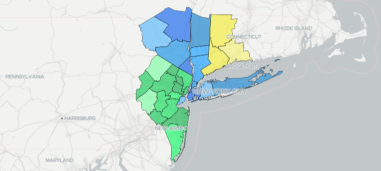
Zooming out to our metropolitan area (aka the “tri-state area,” “NYMetA,” etc.) and things get even more messy: a population of 23 million people spread over 25 counties and four states, with over 12 million living outside New York City and over 4 million living outside New York State. This creates lots of problems: people earning money in New York City and New York State can easily escape its taxes. It makes coordinating regional level solutions to housing and transit much more difficult. It means the municipalities and counties in our metro region can’t build the political clout needed to get things done at the state level because so many of us live in different states!
And what are the results? Our metro region’s tax dollars fund massive corruption. New York is, by some counts, the most corrupt state in the country. We also have the largest amount of debt per resident. New Jersey isn’t far behind when it comes to corruption or debt. Connecticut is, in the words of The Daily Beast, “collapsing.”
Many people blame badly drawn borders for the continued persistence of corrupt, authoritarian governments in the Middle East. (Tragically, misguided U.S. foreign policy hasn’t helped.) We can and should blame outdated political borders for our failing state and local politics here as well.
While that might seem depressing, it’s worth reminding that, over time, borders change, and so does their importance. New trade agreements, political institutions, forms of transit, financial systems, and political alliances have shifted the meaning of borders throughout history. We’re not stuck — but we do need to think outside our borders and build institutions that reduce the cost and increase the effectiveness of regional collaboration. This type of activity is more important than ever because many policy-makers, business leaders, and futurists are predicting that, during the 21st century, networks of cities — not nation-states — will become the primary entities coordinating global political and economic activities. Some people are calling this new political philosophy “municipalism.”
If New Yorkers want to benefit from these new geopolitical trends, we need to build regional, democratic institutions that can represent the interests of all the residents of our metropolitan area.
Yes, we have the Regional Planning Association, the Port Authority, and dozens of other “regional” coordinating entities, but none of them have democratic representation of the public as their core mission: and that’s precisely what we need.
There are many questions to answer: who would New York Metropolitan Area (NYMetA) represent, and how does that representation work? Where and how could it derive economic, cultural, and political legitimacy? Where does it fit in a nation of towns, counties, and states? Could it become its own government layer with its own tax base? Or maybe it could live within civil society: as a political party, a social movement, or maybe a cooperatively run government public policy think tank?
While the idea of a legitimate NYMetA government might seem ridiculous and way off in the distance, the mere idea can be used to challenge the political status quo, which has fortified itself within the existing political borders and relies on our lack of political imagination to retain power.
Discussing and developing a plan for NYMetA enables us to imagine ways outside our antiquated political system that can’t seem to perform simple tasks like keeping the trains running, much less have them running on time.
If New York can’t do it, NYMetA can!
***
Devin Balkind is a technologist and nonprofit executive who works on civic technology projects in New York City. On Twitter @DevinBalkind.
Photo: Department of City Planning

Leave a Reply